I love maps and public transportation. 😄 At World Youth Day, we'll likely be taking the public transport and walking around to get to the different events in Kraków. Here are some resources that may be useful.
Kraków City WYD Site
The City of Kraków has a site with the traffic management plans, special transit service, and pedestrian area maps, among other information. The Polish version of the same website is actually a lot more comprehensive and detailed, but you'll need to run it through a translator. I've merged some of the useful links below:
Downloadable PDF Map
Found on the Polish version of the website, this downloadable map pretty much encompasses all the places relevant to WYD. Hopefully we get a copy of this in print.Pedestrian Traffic
I think the most relevant one for us pilgrims will be the pedestrian traffic maps, especially on the way to the vigil. In some other site they mentioned that pilgrims will be designated a route to walk so that the traffic volume can be balanced among the different routes and so that pilgrims will reach their designated area most efficiently. I suppose we will get that specific route when we arrive, but these maps offer an outline of the routes available.
The page has three maps. The first one is for the Błonia Park, the second is for the Divine Mercy Sanctuary area, and the third one is towards the vigil site. Legend:
- Orange - full road closure for pedestrian traffic
- Pink - half road closure for pedestrian traffic; vehicles on the other half of the lanes
- Green - pedestrian traffic on sidewalks only
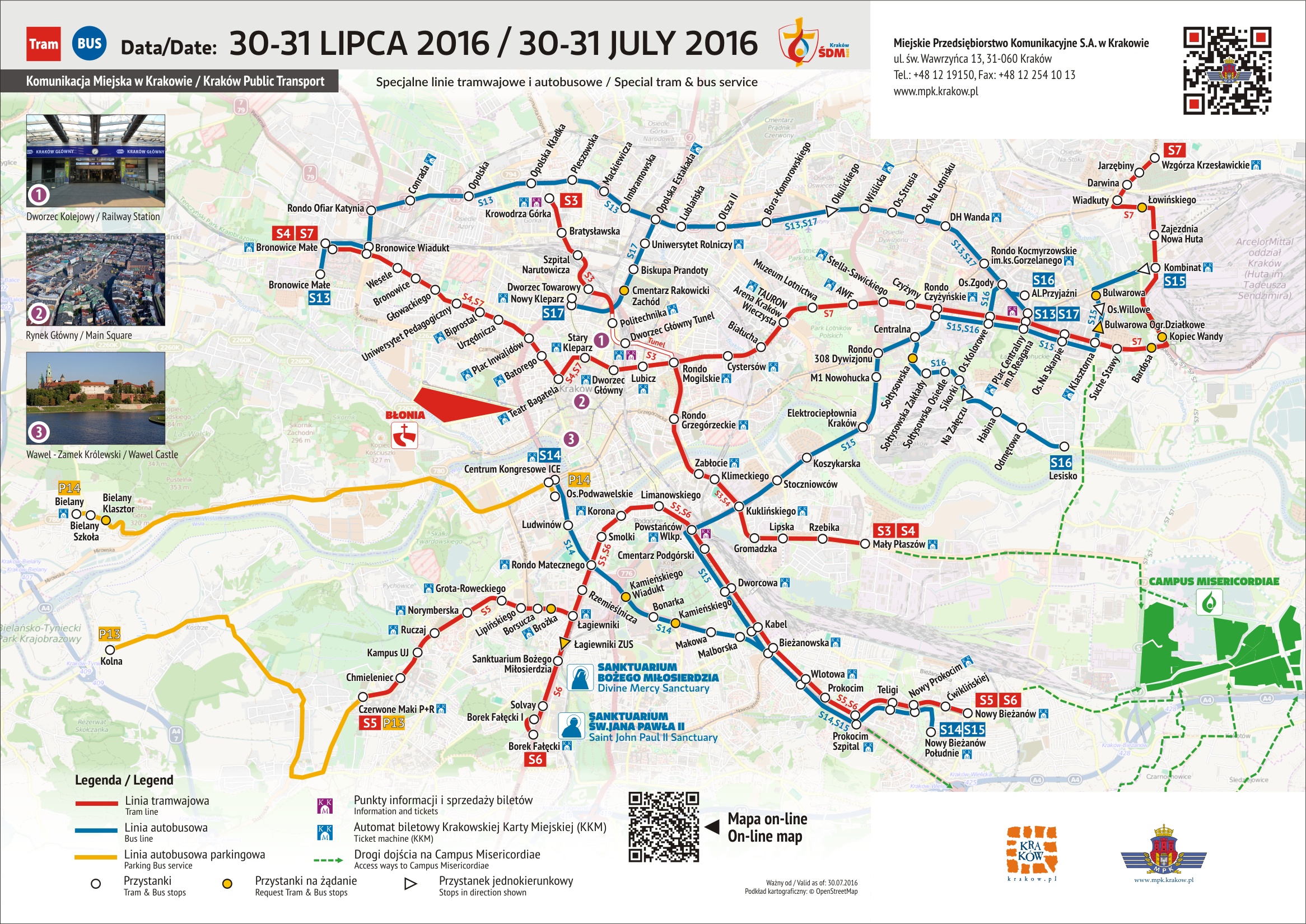
Special Transit Lines
In addition to the regular transit lines, the city is operating special transit lines (Polish version) in order to move WYD crowds to the main events. These lines operate every 3-5 minutes during the daytime. The following maps outline the routing of the special lines.
Pilgrim's Guide to Kraków
This may be the additional book they were talking about in the pilgrim kit video. The guide book contains a nice overview map of the Kraków city centre including the tram and bus lines and stops. However, it doesn't show the line numbers themselves, so it is not really as useful for figuring out where lines go. It also would have been nice to have more streets labelled.
Public Transport Network Map
This is a huge map, containing all the bus and tram routes in Kraków and its suburbs, including what they call "agglomeration routes" (we'd call them "suburban routes"). The nice thing about this one is that it shows the line numbers on the map. Unfortunately, the map is not mobile friendly.
The schedules for tram and bus lines can be found on this site. You will need to know the stop name in order to use the site effectively. Fortunately, you can figure this out on the Public Transport Network Map above.
Public Transport Trip Planner
For getting directions from one place to another place, this is an awesome trip planner system—probably the best one for any city I've come across so far. There's also a mobile version. It's also available for Warsaw (and for Warsaw on mobile).
Great information, detail and user friendly. My, you got this all done in Warsaw! Theresa kicked herself for not reading this before mapping out her own routes in Krakow!
ReplyDelete